| Unit
Home Page
|
Session
Topic 1:
Geography and History |
Session
Topic 2
|
| Unit
Home Page
|
Session
Topic 1:
Geography and History |
Session
Topic 2
|
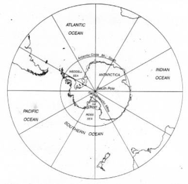
| Antarctica was
the last continent in the world to be discovered. Antarctica is a polar
environment. It is the fifth largest continent in the world and also
it is the coldest place on Earth.
Antarctica is very different from the other polar environment being the Arctic. The Arctic is mostly sea surrounded on its edges by the northern parts of Asia, Europe and North America. By contrast the Antarctic is mostly land, covered with permanent ice and isolated from all other continents by thousands of kilometres. The nearest land is the tip of South America which is 970km from the Antarctic Peninsula. Also Antarctica is much colder then the Arctic. This is due to the very high winds which sometimes get up to 240km per hour. The highest temperature so far recorded is -10 degress C in the mildest region. In this session topic you will learn about what the continent of Antarctica is like. By the end of this session you will know about the history of Antarctica and should be able to locate the Australian bases. Make sure you carefully read all the information before each activity. |
 |
| * To complete this session, you need to work through each activity listed below. | |||
|
|||
| Activity: | |
| - Located and printed 2 copies of the "Blank Map" from the Junior School Server? | ... |
| - Completed your own map of Antarctica, including the bases, oceans and the South Pole? | ... |
| - Completed the "Virtual Tour" and made notes about the 3 different poles? | ... |
| - Made a pie-chart comparing the areas of countries to Antarctica using ClarisWorks Spreadsheet? | ... |
| - Answered the questions on the history of the different Australian bases? | ... |
| - Searched for "web sites" on Antarctica and recorded their URL's? | ... |